Wind River Range, July 2012
</p><p>The nearest town is Pinedale Wyoming. They've got a great outfitter there that can arrange a car shuttle for you. I paid them about $200 to drive my truck while I was hiking to the other trailhead for me so that it would be waiting for me. This was a reasonable price considering that it was about 50 miles of driving with more than half of it dirt roads.</p><p>That's me about 5 miles from the Big Sandy trailhead.</p>")
In July, 2012, I drove out to the Wind River range in Wyoming to hike a segment of the Continental Divide Trail with some thru-hiking friends of mine. The Winds turned out to be the prettiest place I've ever been. I started at Big Sandy Opening and hiked north to Green River Lake, a fairly common 60-80 mile trip (nobody can agree and I think it depends on the route you choose.)
The nearest town is Pinedale Wyoming. They've got a great outfitter there that can arrange a car shuttle for you. I paid them about $200 to drive my truck while I was hiking to the other trailhead for me so that it would be waiting for me. This was a reasonable price considering that it was about 50 miles of driving with more than half of it dirt roads.
That's me about 5 miles from the Big Sandy trailhead.

This is looking south at the mountains I missed. My friends had come through here yesterday.

We hiked up to Jackass Pass to see the Cirque of the Towers. You could actually do this as a long day hike and car camp at Big Sandy. There was also a lake near where the first picture in this album was taken, about 5 miles from the trailhead, that you could backpack to and make the Cirque of the Towers a day hike from your base camp. I think this view was available in less than 10 miles from the car.

We continued north from Jackass Pass down into the valley below the Cirque. Everything was so green and lovely. In all these pictures it looks rather cold with the clouds, but actually it was very warm and it was even warm at night. We had a few afternoon and nighttime thundershowers.

Here I am in a meadow of wildflowers. We found lots of nice mushrooms in these meadows, too, as you will see later.

Here's the valley. There's a lake nearby and we will be climbing up into the green up ahead to Texas Pass, which is above treeline. It didn't take much elevation change to go from meadows to trees to alpine. Elevations in these pictures ranged from around 9000 to 12000 and I think the very end at Green River Lake was around 8000.

Here I am with the Cirque behind me and I think Jackass Pass is also behind me. I'm standing here on Texas Pass. It's very warm. I was a little sorry I had a long-sleeved shirt for this trip.

We saw a little mink on top of Texas Pass. We also saw a few pikas and marmots. We heard more pikas than we saw.

We descended from Texas Pass and camped along this nice river with these awesome crags above. We passed numerous lakes on the way here. We stopped to cook dinner near one lake before reaching our camp. There are supposedly grizzly bears in the area and we decided not to camp where we ate. The others in my group carried bear spray but I just carried the booklet that came with the bear spray. It seemed to me the info in the booklet was actually what would save you and if you ever got to the point of needing the spray, it's probably because you didn't read the booklet.

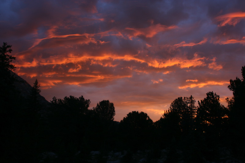
As the evening progressed, someone noticed alpenglow on the crags so we all jumped out of our tents to watch the sun set.

More alpenglow.

There were interesting clouds in the sunset.

My friend Scott and I lingered over the sunset for quite a while. Somewhere in there I have pictures of the people in the group. These are actually Scott's pictures since my camera batteries were all dead. He sent me over 800 pictures and I kind of randomly winnowed them down. There are too many really good ones missing from this album. Hopefully you get some idea how nice it was in the Winds.

Here I am playing my penny whistle for everybody. Since these are Scott's pictures, I actually have lots of pictures of myself.

It rained a little in the night and in the morning we hiked over that wooded pass and up onto this really cool meadowy plain. There were unusual plains, meadows and mountains in shapes I had never seen anywhere else. This meadowy plain really fascinated me from afar. I could just imagine wild mustangs with their manes flowing up here.

Here are three of us in our group of five hiking through a meadow cross country to get up to the meadowy plain. Four of us took a wrong turn and just went cross country to get back on track. CDT hikers get kind of used to this and do it all the time.

Here I am approaching what looks like it might be a wet creek crossing. The meadowy plain undulated and we spent the day hiking up and down gently through meadows, forests, and past lakes and creeks.

Looking back at the crags we've left behind.

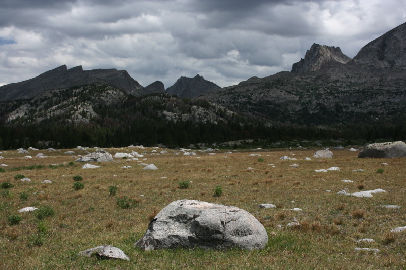
Now we are up on the meadowy plain. Way off toward the southwest we could see into the Wyoming desert. The air is very clean here and you can see much farther than you can when you look off into the desert from the High Sierra. You'll have to take my word for that since there aren't any pictures of the Wyoming desert here.

At a junction, looking north.

Here I am walking through a meadow.

When we returned to the forest, Scott, a mushroom expert, could be hear whopping and yelling. I came around a bend to find that he'd discovered a whole bunch of porcini mushrooms. This is one of them in situ.

Here are four in our group fording a creek.

Another bit of forest and more mushrooms! They looked like little biscuits hiding in the duff.

Here are two of them with a knife for scale. We dug them out and cut off the dirty parts, so these ones have been cleaned. They are quite dense and heavy. Scott says that fresh porcinis like these are worth $85 a pound. We ate some of them raw and they were very good raw. We planned to carry our haul with us and try to saute them in olive oil at dinner time.

Here's our haul. We had several pounds.

In the afternoon it started to rain so we stopped under a small tree near a lake to cook dinner. Here I am cooking the mushrooms on my little alcohol stove. Not all of them, just whatever would fit in my 1 liter pot. Only one other person in our group had a stove and she had already started cooking her dinner so we only could make a liter of sauteed mushrooms.

Here we all are cooking and eating under this little tree. It was dry enough under here. We were all very happy.

Here's a typical lake. We passed lake after lake after lake. It did get a little frustrating to be with these seasoned thru-hikers. They had been hiking since April. They were in the groove and had the thru-hiker mindset of making miles. I really wanted to go swimming.

I think this is the following day. I believe we camped near Hat Pass in a grove of forest full of lots of mosquitoes. After Hat Pass we had a day of climbing up, then dropping down over and over. We passed countless lakes, each with its own personality. Everywhere we looked everything was different and so beautiful we were constantly amazed at the beauty all around us. This lake was particularly memorable with its pretty mirrored surface and rock ledges beckoning me to go for a swim. We didn't stop to swim.

Lots of flowers were in bloom at this time of year. The mosquitoes weren't too terribly bad, but they were out.

It's really nice open country out here.

We climbed to yet another pass, trying to keep a lookout for tomorrow's goal, which was Knapsack Col. I guess when you come out here, Cirque of the Towers and Knapsack Col are the two big things you must do.

We've dropped down again to cross a rather large and wet stream. That's me carrying my hiking shoes. I bought leather hiking shoes for this trip, concerned about not knowing what kind of terrane I'd ben hiking in. My shoes would take two days to dry if they got wet so now I was having to resort to taking them off to try to keep my feet from becoming total prunes.

This lake was feeding that large stream I just crossed. I mentioned really wanting to go for a swim. Later at lunch we finally stopped at a nice lake and Nancy and I went for a little skinny dip. It was so refreshing. It really was quite hot on this trip.

We climbed up to yet another alpine pass.

Finally a picture of some of my hiking buddies.
On the left is Lena from Germany. The Continental Divide Trail is her first backpacking trip ever. She's 26 and has been doing some world travel and thought the best way to see the US was to see the wilderness here so somebody told her the CDT was the prettiest trail so off she went. She was very lonely at first and spent a month trying to catch up to Scott and Nancy, having seen their names in trail registers along the way.
I'm in the middle.
On the right is Eric. In the last 2 years Eric has hiked 10,000 miles. He's hiked the Appalachian Trail, the Pacific Crest Trail, the Florida Trail, the Arizona Trail and by this point, 2000 miles of the Continental Divide Trail. He was very quiet, a man of very few words, but the words he spoke were always extremely intelligent or profound or hilarious. He had been a language expert for the military.

Here we all are except for Scott. On the left now is Nancy. Nancy used to be a dentist but now was retired. Both she and Scott knew each other from hiking the PCT. Scott hiked in 2012. I think Nancy hiked it in either 2008 or 2009 like me, but I had not met her. We had other friends from the PCT in common, though. Hiking with these folks was actually the most fun I have ever had hiking with other people. They were always really great company, very positive and all so different in speed and style and even huge differences in age. It was just a really great time.

Here we are up in the alpine zone. Still looking for Knapsack Col but none of those crags are it.

Some lakes for us to descend to. I'm not sure, but it's possible one of those is where I got to swim.

There's Lena and Eric taking a little break up ahead. They were the two fastest among us. And the youngest. Behind them it looks like sky but it's actually the water of Island Lake far below them.

There's Island Lake. I believe this lake is close to another trailhead. There were dozens of people camped around this lake and lots of people looked clean and dressed well enough to be day hikers.

We hiked around Island Lake and headed up this valley toward Titcomb Lake. This valley leads up to Knapsack Col. I should mention that all these huge high crags were really popular with rock climbers. Some would hire horse packers to haul them in with all their gear. We actually did see some climbers on some of the crags back at the Cirque of the Towers.
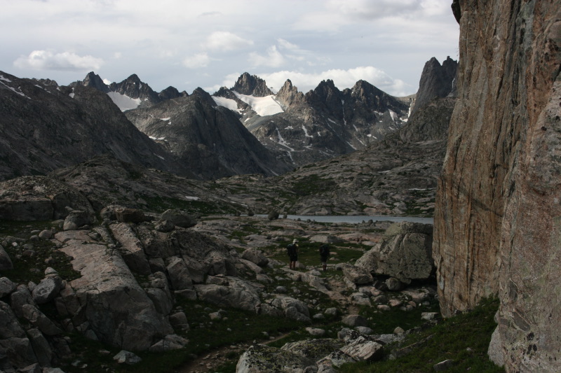

We're now in the Titcomb Lake basin. There were multiple lakes of various sizes all along the way.

We took a break by a small lake for dinner. Nancy took this picture. At the far end is Scott.

There's the view we had while we ate dinner.
 to find our campsite. Every night, Eric would choose a campsite for us since he was fastest and was really good at estimating a spot big enough for 5 tents. Knapsack Col is further up that canyon somewhere out of view.</p>")
Continuing up to Titcomb Lakes (this might even be one of the Titcomb Lakes) to find our campsite. Every night, Eric would choose a campsite for us since he was fastest and was really good at estimating a spot big enough for 5 tents. Knapsack Col is further up that canyon somewhere out of view.

You can see the U shape from the glaciers.

Here I am with my tent. I wear a skirt over my pants when the mosquitoes are biting my legs. It turned out what appeared to be mosquitoes here were actually some kind of strange flying insect that didn't bite at all. It was a really warm and lovely evening and we all sat outside our tents for a long time watching the light play on the cliffs and clouds.

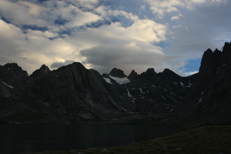
There's our sunset

More of our sunset and Titcomb Lake

In the morning we set off to go climb up and over Knapsack Col. It was a long way going up this valley. This is looking back toward where we had camped the night before. We had camped at the far end of that lake.

The crags around us.

We've climbed quite a ways now. This is Eric standing in front of a really U-shaped valley.

Here I am aiming for Knapsack Col. Knapsack Col is right in front of me. We had to climb that snowfield up and over where the rock band is thinner in the left 1/3 of the picture.

Here's a view of the snowfield we had to climb. It's almost vertical near the top. I was quite afraid. I didn't know how to walk on vertical snow and none of us had ice axes or anything like that.

There I am hiking near the big rocks. These rocks and even bigger ones were all incredibly loose. At one point I could not figure out how not to slip and fall in the snow so I attempted to find a way through the boulders. That was extremely dangerous as they were loose enough to be moved with a pinky finger. I thought for sure I'd end up like Aaron Ralston so I got the heck out of the rocks and back on the snow. Scott told me how to walk on the snow, hollering instructions from way above. I chopped steps in the snow with one foot, one step at a time, making little platforms for each foot. I was so terrified I had to stop and cry for a few minutes before I could continue.
This picture is me, once I'd completed the climbing in the snow. The rest of the way was all boulders.

Here I am finally off the snow, climbing through the boulders to get to the top. These boulders were less loose, fortunately.

This is looking down on the snowfield from above. There are two specks which are hikers coming up.

It was really cold up here on top. I sat here for about 40 minutes waiting for the others to arrive. I was too scared to see what awaited on the other side of the col.

This is what awaited on the other side of the col. This is Nancy in front of Stroud Glacier.

There's Scott with the glacier off to the left and the view stretching out forever.

Here I am freezing my ass off in front of Stroud glacier.

We're going to descend through all these rocks, no trail, to those lakes down there. Those lakes are the headwaters of the great Green River. The same Green River that flows through Utah and into the Colorado River.

Here we are descending over a snow field

We took a nice break to dry our things and have a little lunch in a pretty green meadow part way down. Here I am with my old lady glasses trying to read my maps. I just followed everybody and had no idea where we ever were. I would mark down where we had been on my maps so I could maybe some day come back.

We hiked along these lakes. Sometimes we would lose the trail in the marshy meadows. Lots of pikas and marmots around these parts.

Their maps showed a trail on both sides of the lake. This side of the lake had a big slide. We forged on ahead but this slide was a bit scary.

Up high is Lena. Nancy and I could hear her panicking over the dicy loose boulders. So Nancy and I decided to hug the shore of the lake. I was a little panicky over the possibility that Lena might send one of these loose boulders on top of us.

I forget the name of this lake at the headwaters of the Green River, but you can see that it's Green. The reason the Green River is called the Green River is because the water was actually green from the glacial flour from Stroud and the other glaciers up there. The rocks were full of green crystals. The milky Green River had a minty hue from these green rocks. Scott never quite captured the pretty green milky color of the Green River but he caught the green of this lake.

Here I am walking in more snow.

It was a long long way down from Knapsack Col back to rejoining the official CDT. Knapsack Col is just a suggested alternate route. Somewhere along the way down, it began to rain very hard so there weren't any pictures. The whole biome changed on this side of the Col though. It was much moister over here, more like the Pacific Northwest. Scott stopped every so often to show us yet another amazing variety of mushroom. We saw so many kinds, some very unusual ones. We also started seeing huckleberries with fruit, not yet ripe.
You can see the dead pines from the pine bark beetles. There was quite a lot of devastation throughout the entire trip.

We stopped under some trees once the rain let up a little bit to have dinner. Eric and I took a moment to praise the warmth and dryness of the sun. Some sun salutations, I guess.

This far down the canyon, the Green River is a mighty river. We crossed over a very nice wooden bridge.

Now the rest of our hike together would be spent following the meandering Green River through this incredibly picturesque valley.

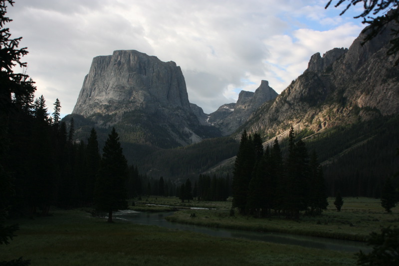
We camped below this monolith that is called Squaretop Mountain. Our campsite had more porcini mushrooms which I collected to take home with me. We camped right next to the river. It was a warm and lovely night with rain at night but no tent condensation. I just love that.
The next morning it was a little clearer.

Squaretop Mountain.

Squaretop Mountain.
Why this wasn't a national park we didn't know. It should be in every Sierra Club calendar it was so picturesque and beautiful.

Just before we reached Green River Lake we met these bull moose.

There was also a cow and a calf moose. They ran away before I could see them. I'm glad Scott got pictures of them. The calf is so cute!

You could drive up to see this view, hiking in only a mile or so to get this exact picture.

Closer picture of the moose. We kept our distance. Moose are pretty dangerous.

Lena is hiking the trail above Green River Lake. We hiked along the lake for a little while longer until we reached the trailhead. Sadly, the Pinedale Outfitters car shuttle service had come through and I wouldn't have an excuse to keep on hiking with my friends. I sadly said good-bye to them at my car and drove home.
It took about 20 hours of driving to get home. I stayed at a KOA in Beaver Utah. It was a pretty road trip and my porcinis made it home through the desert in my cooler in the back of my old manual transmission, 2WD pick-up truck that has no air conditioning.
I hope someday to return here. This was absolutely the most beautiful place I have ever hiked.